|


|
|
The Climate of the Canarian Islands
In the Canarian Islands, there is eternally spring time. This is at least what is said and the way the Canarian Islands advertise in order to attract the holiday makers during the whole year. The fact that in the areas of the equator there is a tropical climate during the whole year is as known as the fact that in the Arctic and the Antarctic, there is winter during practically the whole year. But how can be spring time during the whole year on an island that is not far located from the west of Africa, when in the same geographical latitude, a few kilometres further to the east, in North Africa, there is the dry and hot Sahara desert? 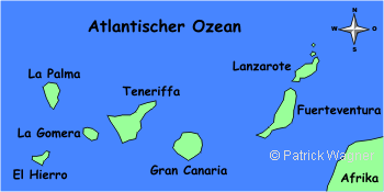
There are two effects that influence the climate in the Canarian Islands decisively and provide a completely different climate as in the nearby Sahara-desert in Africa: the north-east trade wind and the Canarian river. The north east trade wind provides during nearly the whole year a cool breeze from north-western direction. It not only provides a cool wind to the hot region but also humidity, so that there are rainfalls. The Canarian river is an ocean current that provides some fresh, cool and nutricious water from the nordic regions to the Canarian area. Refreshing winds, fresh and cold sea water, this sounds deterring! But what would be the Canarians without north-east trade wind and Canarian current? One can see it a few hundred kilometres further to the west in the Sahara-desert: absolute dryness, aridity, heat, 40-50°C in the summer time, no rainfalls, no plants. In the Canarian Islands, there are tempertures between 20° and 25°C during the whole year, thus pleasant spring temperatures. Only rarely the temperatures rise to 30°C. But during the winter months, the temperature can also sink down to 15°C. Thus, one should never travel to the Canarian Islands without a jumper or a coat in the luggage! Thanks to the Canarian curremt, the water temperatures are very even during the whole year; With some water temperatures between 19 and 23°C, one can bath in the sea during the whole year. While in the Caribbean, the water heats up in the summer time up to 30°C as in a bath tube, the water temperatures in the area of the Canarian Islands seldom rise to 25°C due to the permanent sea current. 
In the Canarian Islands, it hardly rains during the summer months and/or it doesn't rain at all. In the spring time, autumn and winter there are some rainy days; one can never know if one is not suprised during a hiking tour by a sudden rainfall. 
The Canarian Islands are located so close together that it is possible to look from one island to the other. But the climate still differs considerable from island to island. Those islands with very high mountains (La Palma, Tenerife, Gran Canaria, La Gomera, El Hierro) have much more rainfalls than the flat islands Lanzarote and Fuerteventura. There, where rain does fall plants do grow, the agriculture is practised and the nature is bright and green. The high mountains of La Palma, Tenerife and Gran Canaria force the nort-east trade wind to get up and therewith to release rainfalls. While the flat islands Lanzarote and Fuerteventura have a uniform climate in practically the whole of the island and also a uniform and scarce vegetation, there are different zones in the mountaneous islands: in the north/east where the trade winds accumulate there are much more rinfalls than in the south/west. The sky in the north/east is oftenly clowded and the flora is bright and variated. In the south/west to the contrary, there is dryness and aridity; many times, it is possible to lay a couple of days on a beach in the south/west while there are rainfalls in the north/east. The Planetary Wind System in the Proximity of the EquatorWhen the spring time begins in Germany, the sun is located at the equator in the zenith, Which means it radiates vertically from the sky right down to earth. Through the direct sun radiation, the land underneath is very strongly heated. Of course, the air masses close to the ground are also heated by this vertical sun radition. By this warming, the air is stretched and ascends (see ascending vapour from a cooking pot with boiled water). 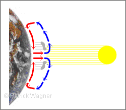
The air that is ascending over the equator gets into increasingly higher air layers with increasingly lower getting temperatures. By this way, the ascending air slowly cools down. But as the cold air can contain less water than warm air, the exceeding water condenses and clowds are originated. By this way, the strong storms and rainfalls daily occur in the tropical areas. The ascending air can get a height of up to 15 km. Then, the ascending airflow is subdivided to one partial flow to the south and another one to the northern direction. These high airflows move for some thousands of kilometres in northern and/or southern direction before they descend again. The descend takes place in the so called subtropic; As during the descend, the air gets into warmer realms it can increasingly absorb more humidity. This is the reason why in those areas, there are extremely few rainfalls; they are very dry areas due to that. At the northern hemisphere, these airflows fall off in the Sahara desert; this explains the lack of rainfalls and the dryness. Thus, when the sun radiates vertically from the sky over the equator, there is continuously warmed air ascending. Due to that, an air hole is generated close to the ground that continuously absorbs some air from north and south. Thereby, the air circulation is closed. Thus, the sun is the driving force for the whole wind and weather system in the proximity to the equator as also in the regions at a few kilometres north and south from the equator. The area of the vertical sun radiation is called by the metereologists also as the metereologic equator, because as known, the sun only radiates over the equator vertically from the sky only at the beginning of spring and autumn time. In the summer time, the sun is located 23,5° at the north of the equator vertically from the sky, in the winter time, from the south respectively. These latitudes are called northern and southern turn radius. The meteorogical equator moves every year up and down between these turning radius. The North-East Trade WindIn the previous chapter we learned that through the vertical sun radiation at the metereological equator, there are permanently some airflows descending and move with a huge height to the north and the south and some thousand kilometres at the north and/or south they descend again. At the ground, a permanent flow moves from the north and/or from the south to the equator in order to nutrate the ascending airflow. 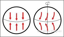
If the earth would not rotate, it would be possible to observe at the north of the equator north winds and at the south of the equator south winds. But actually, at the north of the equator there are winds from north-east and in the south winds form south-east. This is the result of the Coriolis force, that deviates the northwinds (winds coming from the north) of the northern hemisphere to the west and deviates the southwinds (winds coming from the south) to the east (on the southern hemisphere the way around respectively). The Canarian Islands are located at approximtely 28° at the north of the equator, this corresponds to a distance of approximately 3000 km. Therewith, the archipielago is located at the edge of the area, where the airflows of the ground coming from north/eastern direction continue moving in direction to the equator. Thus, in the Canarian Islands, the north/east trade wind dominates the wind direction in most of the days. As the north/east trade wind is a ground airflow, it only gets a height of 1200-1500 metres. The Coriolis-ForceThis chapter is dedicated to all those who want to know exactly what is a Coriolis-force. Everyone has already heard this term but almost nobody can explain it; it is like the offside rule in football. I will first explain the Coriolis-force by an example of the daily life, then I come back to the earth. Imagine, you are standing on the middle of a rotating carousel. You are firmly standing there, even if you are rotating. To the contrary, another one who is standing at the edge of the carousel will have a hard time. He is not only rotating around the centre of the carousel but also has a high circumferential velocity. The so-called centrifugal force even drives this person further out. Now imagine that you jump out from the centre of the carousel. What happens to you? You jump from the quietude to a wheeling carousel floor, thus you experience at this moment a velocity at your feet. On order to avoid the floor slipping from your feet you need to bring up some force that is the coriolis-force. Once you provide this force into the circumferencial direction, you are still far from standing firmly as, with the obtained adhesion, the centrifugal force will try to throw you to the outside. In order to avoid this, you have to bring up the so-called centripetal force in direction to the centre of the carousel. 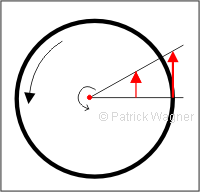
Although on the carousel, you only do a step from the centre to the outside, you have to provide the coriolis-force,as your circumferential velocity changes. You will experience this force by each further step on the carousel at which you change the distance to the centre of the carousel. What applies to a flat carousel of course also does apply to the earth as a globe. By standing on one of the earth poles, you rotate in 24 hours by 360° but you do not have a velocity. To the contrary, by standing on a spot of the equator, you will make a distance of 42.000 km in 24 hours. Your velocity is 1.670 km/h, thus faster than every common plane. Thanks to god, the air above you will move with the same velocity; otherwise, it would blow you pretty much. Thus, a small air package that moves from the north pole to the equator has to built up during its journey an east/west velocity from 0 km/h to 1.670 km/h. While during your moving from the centre of the carousel to the edge you can firm up with your feet at the ground of the carousel, the air in the atmosphere has nothing with which it can firm up. It will be simply drifted to western direction, which means that the ground moves under it in eastern direction. The way around, an air package coming from the equator starts its journey to the north with a radial velocity of 1.670 km/h. A few kilometres further to the north, the velocity at the ground is of only 1.650 km/h. Thus, the air package is faster than the earth under it, thus it moves to the east. In resume it can be said that on the northern hemisphere, an air package that moved to the south is deviated to the west, while an air package that moves to the north will be deviated to the east. As consequence, there are mainly north/east winds at the north of the equator, thus winds coming from the north/east. At the southern hemisphere, the circumstances are just the way around. A small addition for the fans of astronautics: Why do the European Ariane-rockets actually start from French-Guyana and not from somewhere in Europe, where they are built? The reason is not the emptyness of the Atlantic Ocean for the case a rocket crashes, but the location of French-Guyana in the proximity to the equator. The starting rocket gets actually a circumferential velocity of 1.670 km/h on its way and this saves a lot of fuel. The same reason is why the American Space Shuttle also starts at the southern tip of Florida, thus in the proximity of the equator. The FoehnThus,on the Canarian Islands, there is practically the whole year a wind from north/eastern direction. It is clear that this is the reason in the south/west of a Canarian Island there are less strong winds as for example in the north/east and/or at the northern and the southern edge. This is also why the water in the lee of the volcano mountains there is respectively less wind. On those Canarian Islands with some high volcanosin the centre of the island, another effect occurs due to the North-eastern trade wind: the foehn. The inhabitants of the German pre-alpine countries experience on countless days per year a pleasant foehn weather. If there is foehn weather, there is a wonderful view from Munich up to the Alps; a warm and dry wind comes from the south. Many times, the temperature is 5 - 10°C warmer than 100 km further to the north. How is a foehn originated? 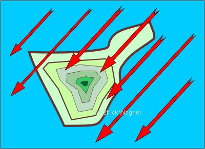
When air comes up, it cools dowm for approximately 1° C per each 100 m height. Those who are in the summer time in a plane that is starting from Tenerife at sea level and 30°C, will read at the plane screen at a flight height of 10.000 m an outer temperature of -70°C, thus a difference in the temperature of 100°C; Respectively, the temperature of a descenting air package increases by approximately 1° C each 100 m. The ascending air cools down due to the reason that the air pressure decreases. But cold air can save less water than warm air. Thus, if warm and humid air ascends and cools down, the dewpoint is somewhen reached, that means that the air cannot save anymore the water it is containing and releases it in form of drops; clowds are formed. Those who breathe out in the winter some warm and humid air will experience with the clowd of breath exactly the same effect. In that moment when air condensates out some water drops, the so-called condensation warmth is released. This energy is saved in the air; it was provided by the sun when it vapoured the water that absorbed the air. If the air ascends that condenses the water out at a height of 100 m , the temperature does not sink by 1°C but only around 0,6°C. Thus, the released condensation warmth keeps the air warm. The water that was condensated out falls down during the ascend upwards in form of rainfalls. If the dried air descends again behind the mountain, it increases by 1°C per each 100m difference of altitude. As during the ascend the air already released the water it contained, it is now very dirty and warmer. 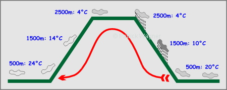
As an example, we will take the airflow that, coming from the north/east at a height of 500 m, it comes across to the barely 2500 m heighted mountain chain of Tenerife. Let us suppose the air comes with a temperature of 20 C° at the north/east beach of the island. The drifting air slowly ascends at the north-eastern hillsides of the island and cools down per each 100 m for 1°C. At a height of 1500 m, it only has a temperature of 10°C. At a height of 1500 m, it also reached its dew point, that means, it cannot continue storing the water in contains if it continues cooling. As a consequence, the air condenstes the water out, some clowds are formed and the air colls on the next 1000m only for about 0,6°C per each 100 m. At a height of 2500 m, the air crosses the Teide National Park with a temperature of 4°C. At the following descend, the air warms up again for 1°C per each 100 m, so that it arrives at a height of 500& m with 24°C as a very dry and very warm foehn. The crossing of the National Park that is located at a height of 2500 m indeed cost the air a considerable amount of water; but therefore its temperature increases by about 4°C. The Sea and the Sea GroundBy looking from the African westcoast to the Atlantic Ocean, we will see at the west of the Sahara the Canarian Islands and some thousand kilometres further to the south the Cape Verde islands. In between, there seems to be nothing but water; Except the fact that both archipielagos consist on volcanic elevations, nothing else seems to be common between the Canrians and the Cape Verde. But by looking at both archipielagos from the point of view of a oceanologist or a metereologist, the Canarian Islands and the Cape Verdedo have a lot in common. Both archipielagos stand on a huge abyssal, the so-called Cape Verde plateau. If the mean sea level would descend for 4000 metres, there would be a huge flat with the Cape Verde and the Canarian Islands at the northern and southern edge. Those who dive for several thousand metres to the sea ground will not see, as it is the usual case, metres-thick mud but red brickearth that consists on fine grain of sands of the Sahara. The Canarian Islands thar are located at the west La Palma, El Hierro, La Gomera, Tenerife and Gran Canaria are each independent mountains that rise from the ground of the Cape Verdian sea level. Accordingly, the Teide in Tenerife is not a mountain of height of 3700 metres but rather a seven thousander. The islands close to the coast as Fuerteventura, Lanzarote and some small spots of earth are located on a common underwater-plaeau in a depth of approximately 1500 metres; thus, in a certain way, they belong together. The Canary CurrentIn the chapter of the North-East Trade Wind we have learned that in the proximity of the equator, there are permanently air masses coming from the north/east and the south/east in order to provide fresh supply to the ascending and warmed-up air. It is self-evident that these east winds also provoke the respective ocean currents. Equatorial currents are those sea currents that are, in the proximity of the equator, every year driven by the trade winds into western direction. Such a sea current keeps its direction even if in between, there is a different direction of the wind. 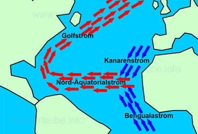
The equatorial sea currents continuously transport the water of the surface from the west side of one continent to the east side of the neighbour continent. Thus, in the Atlantic Ocean, wter flows from the west coast of Africa right into the Caribbean. This is why the sea-level at the east coast of North America is higher than the one of the west coast of Africa. In order to continuously provide the northern equatorial current with sea water, at the west coast of Africa, the Canarian current flows from the north/east and the Benguala current from the south/east. The Canarian current flows right at the Canarian Islands and between them. It comes from the north/west coast of Africa. The offshore winds in the proximity of the coast blow the surface water out to the sea, so that the deepwater comes up. But deepwater is rich in nutrients so that around the Canarian Islands there is an abundance of fish. The coming up deepwater has a clearly lower temperature as the deepwater and the air above it. In the area of the Canarian Islands, it does not only provide some parmanently plesant water temperatures but also some modified air temperatures. It is actually due to the cooling effect of the cold water that in the Canarian Islands, there are not 40-50°C in the summer time, as it is the case in the Sahara desert at a few hundred kilometres distance, but bearable 25-30°C. 
Back to the index Gran Canaria Back to the index Fuerteventura Copyright: Patrick Wagner, www.tourist-guide.biz |
||