|
|
|
A Round Trip in the North of the Island
In order to explore the northern part of the island we start a little round tour from the bathing resort Corralejo, drive over to the west coast of the island, then across the centre of the island in direction to the capital of the island Puerto del Rosario in order to enjoy then the highlight of the day that is the natural protected and unique dune island El Jable shortly before Corralejo. 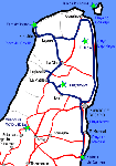
Concerning this tour I would like to mention in advance that the landscapes and the places in the north of the island are far from being able to keep up with the ones of the centre and the south of the island. A real highlight in the north of the island is the mentioned dunescape at the south of Corralejo, that is so unique and spectacular that one can spend there a whole day or even a complete holiday. There are not some huge hotel buildings and appartment complexes right at the northern end of El Jable for nothing. CorralejoWe start our tour in the second biggest tourist place of the island, Corralejo. Those who spend their holidays in another part of the island should better omit this part of the island, as Corralejo is not worthwhile to travel to. In the 50ies and 60ies, Corralejo was still a tiny fishing village, not earlier than the 70ies and 80ies the buildiong boom started, so that Corralejo became a huge holiday centre, the second biggest of the island. It is a typical tourist place where one does not meet any local people except those who found a job in the hotel, a restaurant or in a tourist shop. 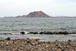
Due to two reasons, Corralejo has made the sensational lift to a touristical centre: there are, on one side, the eternally long sandbeaches in the dune area El Jable, and on the other side, the sound El Río between the island Los Lobos and Fuerteventura offers an ideal place for water sports and diving. On the main road from Corralejo, the restaurants, bars and tourist shops string tightly together as a pearl necklace. During the day, there is permanently a traffic jam and one can smell the exhaust gases. It is more pleasant to be in the big beach playa de Corralejo, where one finds some calmness on a kind of boardwalk; Either one really likes places like Corralejo or one fully avoids them; I do not recomend an extra excursion for visitng this place, specially not if one already lives in another touristical centre of the island. Lajares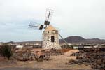
From Corralejo we drive a piece to the south in direction to La Oliva in oder to turn to the west on half of the way; We drive through a wide barren land until we finally arrive at the small village Lajares. Already from a distance we see a beautiful windmill which we spontaneously approach. It is a typical windmill of which there a lot in the island. In former times, the grain was ground to wheat in order to make Gofio of it. We discover a second windmill and enjoy to have a close look at the restored windmills. The main reason why we have a stop in Lajares is the famous hand craft school Escuela de Artesanía Canaria. This training centre for embroidery is a part of a big souvenir shop where one can get some authentic gifts of the island for not very cheap mopney. But not only embroidery is sold there but also other products made in the island as for example oven ware, basketry or locar costumes. CotilloWhile we quickly experienced Lajares during our drive, we made a long extended stop in Cotillo at the north west coast of the island. Cotillo is a small fishing village where bit by bit, some appartment complexes have been built so that slowly, the tourism arrvies here too, but not to such an extent as it is the case in the other tourist centres of the island. Cotillo neither is a beautiful nor an idyllic place, but there are some things to see and we find a beautiful beach. The historical meaning of the place is based on the lime export. Still today, it is possible to view some lime ovens at the outskirts of the place. Lime was the only economic good of the place and it was exported with ships. look at the narrow harbour bay will immediately notice that the place had a natural protection against the assaults of pirates: in this narrow bay with a reef at the front, only the local people could find the way; pirates did not have any chance; Anyhow, at the outskirts of the place, a small fortification castle was built, the Castillo de Tostón, in order to repel the pirate attacks. We also enjoy to view this old bastion. We are really delighted by the golden sandbeach Playa del Castillo, that invites us to bath and have a walk. But we keep this highlight for an hour, as we first do a piste trip to the north west tip of the island, the Punta de Tostón, where we enjoy the light house and the view to Lanzarote. We can drive back to Corralejo with a jeep alongside the northern coast,but we drive back to Cotillo, where we now afford a short stay on the beach in order to be recovered for the further driving. Tindaya - the holy Mountain of the Guanches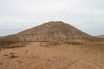
From Cotillo, we continue driving to Oliva, where we have a look to the big parish church provided it is opened. But our next destination od the 397 m heighted Montaņa de Tindaya, the holy mountain of the Guanches, after which also the place that is located at the bottom of the mountain is named. We contemplate the majestic volcano hill from a distance, but it is also possible to climb up this mountain! In order to climb up the mountain one either needs the permission and also a guide. Those wearing sandals or flip flops should not even start to climb up the mountan; this mountain is something for experts who are free from giddiness and sure-footed. On the way to the peak, the petroglyphs of the Guanches are visible and one also finds some remainings from the old sepulchres. From the peak, one also of course enjoys a dascinating view all over the whole north of the island. The View Peak TemejerequeFrom Tindaya, we drive in direction to the capital Puerto del Rosario. Shortly before we arrive to the place Tetir, a small signposting leads us to the view summit Temejereque. On this mountain heighted 511 m, there is a radio antenna station to which we can easily drive to. We pleasantly do this short side trip, as from this circled peak we have a great panorama view to the whole north of the island and over some wide parts of the centre of the island. Salinas del CarmenWe contuinue driving in direction to the capital Puerto del Rosario, but we circle it on the well arranged by-pass in oder to continue alongside the coast in southern direction. For german standards, the capital of the island is certainly a small city with a big harbour, but during our stay in Fuerteventura we willingly avoided to make a real city tour. 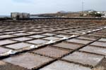
Thus, we countinue driving through dull land in southern direction until we finally arrive at the Salinas del Carmen. Here, one can view how salt is gained from the seawater. The complex certainly only still operates for museum purposes, but it is interesting to see how the seawater is redirected from pool to pool, how the water slowly condensates and in the back pools the salt can be shoveled. What is pleasant is that it is possible to walk on the bricked stone borders of each of the basins, so that is was possible to have a close look to everything. We did not drive so many kilometres to the south in order to see the Salinas del Carmen, but we wanted to experience this small attraction before getting to the main attraction of our day excursion. Parque Natural de las Dunas de CorralejoComing from the south, we circle the capital Puerto del Rosario in order to drive back to Corralejo alongside the coast. And we really look forward to the last 10 km, where the dream world El Jable extends at the left and the right side of the roadway. I intentionally choosed the tour this way, so that we discover this national park form the south, as by this way, one drives deeper into the slowly emerging sand dunes and gets to the peak shortly before Corralejo. This is much more interesting than driving straight from Corralejo to El Jable. 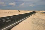
It is fascinating how the dark asphalt road suddenly appears at amidst the dunes of white sand. At the beginning, one can still look down to the sea; there are repeatedely possibilities to have a stop where one also can get straight to the beach. The unique thing of these dunes is that they straight merge with a big beach, thus, one can simply walk over the dunes up to the sea and spread one's towel there. Shortly before Corralejo, the white dunes are so wide that one only sees the sea from a distance. There are enough parking possibilities; one simply parks the car at the side of the road and walks in direction to the sea. Then it can easily take 10 minutes until one gets to the actual beach. but such a hiking tour through the dunes simply belongs to a holiday in Fuerteventura, and here, one fells like being in a desert where there is nothing but sand and some dry plants. he beaches are of course as beautiful as they are long; Numerous batherners are spread over the widely extended beaches. There is only to be careful on the way back to find the car, as one's footsteps are long-ago gone with the wind. 
Back to the index Fuerteventura Copyright: Patrick Wagner, www.tourist-guide.biz |
||