


|
|
General information of the island Lanzarote
Every year, millions of sun-seeking seaside vacationers spend their holidays in the volcanic island Lanzarote. In Lanzarote there are countless beaches from which a part are really dream beaches that make a seaside holiday to be a pleasure. But Lanzarote is not purely a bathing island; there are also many sightseeings starting with the volcanos and fields of lava, view points with unforgettable panorama views and picturesque little villages and even museums. 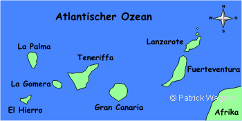
In Lanzarote, the mass tourism started much later than in the other Canarian Islands as Gran Canaria or Tenerife. Thereby, the island was spared from arquitectural abberations as 10-floor tourist bunkers and to a large extent, Lanzarote could keep its original character. Today, there are also still many buildings built around the big tourist centres, but it is done in a rather nice and urbane way. The people of Lanzarote, the "Lanzaroteños" highly aim to keep their island to be beautiful and according to its original chatracter. A big part is under environment protection, in many little villages, the aim of the inhabitants to make their village/island to be a real piece of jewelry, is remarkable. This is noticeable by the planted waysides, by the palm avenues or by the wonderfully adorned houses. A few general data about LanzaroteWith nearly 800 km², Lanzarote is the fourth biggest Canarian Island. There a only 120 km to the African west coast, the neighbour island Fuerteventura is only 10 km away. In the north of the main island, there are three further islands (thereunder La Graciosa) off the coast, at the south, one can see the island Lobos before Fuerteventura. )
Lanzarote is purely a volcano island that was originated in the course of millions of years by numerous volcanic eruptions. The surface of the island is covered with numerous volcanic mountains and fields of lava of a completely different age (see chapter Origination of Lanzarote). Although the abundance of volcanos, Lanzarote is, compared to the other Canarian Islands as Tenerife or La Palma, a flat island. The highest mountain named Peñas del Chache is located in the north of the island, in Risco de Famara, with a height of barely 670 m. Due to their little altitude, the mountains of Lanzarote are no resistance for the higher trade wind clowds, so that they cannot be forced to ascend and to release the moisture as rain. This is the reason why in Lanzarote there are not two climate zones (a humid one in the north east and a dry one in the south west) like in the other islands with high mountains.The island is very dry and is considered to be waterless; from all Canarian Islands, Lanzarote is the one with the least rainfalls. Approximately 100.000 people live in Lanzarote, from them, approximately a half live in the capital Arrecife; Each tenth inhabitant is of german nationality! Additionally, there is a yearly average of approximately 50.000 tourists but in the main season, the number of tourists exceeds the number of the inhabitants. The tendency of all figures is increasing. Brief historical overviewThere are no aboriginal people of Lanzarote that can be prooved with some kind of stone-aged findings. The island was rather populated in the beginning of the first millenium AD by immigrants. European conquerors came from the 13th century regularly to the Canarian Islands; the main motivation was the slave trade. Numerous inhabitants of the island were transported to slavery by the conqueror's vessels. In the year 1312, the Italian merchant Lancelotto Malocello settled down on the island. ieder. The island Lanzarote was named after his first name. For his protection, he built the castle Castillo de Guanapay at the upper side of Teguise, that still today can be accessed. In the 15th century, Lanzarote was conquered by the spaniards, as the other Canarian Islands; While the fertile islands La Palma, Gran Canaria and Tenerife were administrated straight by the Queen Isabella, the dry islands Fuerteventura and Lanzarote were controlled by lords and brought to economic ruin. Of course, the spanish conquest also meant the end of the native culture. In the following centuries, numerous rebellions and tumults occured in the island. The economical successes were repeatedly knocked down, partly by some dry periods and partly by plagues of locusts. A definite economical breakdown took place after the massive volcanic eruptions in the year 1736, where the most fertile parts of the island were inundated by a lava coat with a thickness of several metres. After the eruptions, the inhabitants of Lanzarote succeed with the dry field cultivation in cultivating wine and exporting it, in order to activate the economy halfway. In the year 1912, Lanzarote got the right to self-administration; the fishing became the most significant economy factor. But under the dictatorship of Franco between the years 1939 and 1975, the Lanzaroteños were equally repressed as the other inhabitants of Spain. In the year 1982, Lanzarote became autonomous again (compare with the status of Bavaria within Germany). The tourism developed to be the most important economic factor. Landscapes in LanzaroteOne could think that a volcanic island as Lanzarote is of a monotonous landscape with a lava dome here and there and without offering much diversion and sightseeings. Due to the different age of the mountains and plains and the multifaceted forms of the volcanic mountains, in the course of the time, some areas of completely different characters developed. National Park Timanfaya The most spectacular landscape is offered by Lanzarote at the Parque Nacional de Timanfaya. Here are the Montañas del Fuego, the fire mountains, that covered a district of the island with lava in the years 1730-1736. There is hardly another place in earth where one can experience a complete volcanic area so closely. Depending on the sun radiation and the exterior temperature, the fire mountains in mnay coulours from fire red to deep black. 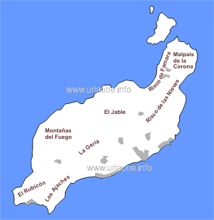
Wine-growing district La Geria Right beside the Montañas del Fuego (fire mountains), there is the wine-growing district La Geria, that is covered by a thick lapillus coat since the eruption from 1730-1736. Today, here is wine cultivated in the dry field cultivation. La Geria either offers a fascinating landscape as also some impressive views to the big wine fields that go up to the volcano hillsides, as also very good wine to try and buy. El Jable At the north of the National Park and the wine-growing district La Geria, there is the district El Jable. In the long extended bay of Famara, one finds some wide sandy beaches and sand dunes that widely extend into the heartland; this is the reason of the french name Jable (= sand) for this area. One gets the best view to this landscape from the Mirador Ermita de las Nieves. Risco de Famara In the north west tip of the island, the Risco de Famara (Risco = Kliff) stretches out over with the highest peak of the island, the Peñas del Chache (670 In the west coast, the mountains fall cliffy down into the sea. In the mountains, there is a fascinating street with numerous view points down the coast to the rest of the island and to the neighbour island La Graciosa. In this mountains, some clowds release their humudity as rain from time to time, so that this is the greenest and most humid area of the island. Malpaís de la Corona At the north east tip of the island there is the Malpaís de la Corona (bad land of Corona) with the distinctive peak Monte Corona. Here, the visitor steps into a 3000 year old lava area and gets an impression of how long the vegetation needs to let some simple bushes grow on a lava field after a volcano eruption. In the Malpaís de la Corona there are also the famous lava tunnels from which one can be accessed as the Cueva de los Verdes. The Rubicón and the south west coast In the very south of the island one finds a completely flat plain without any vegetation on which there are only a few single houses; Not a bit beauty, but it is still fascinating how a wide area of the island is simply fellow and dry; At the north of it there is a lava field of a length of several kilometres that extends from the fire mountains up to the west coast. The lava field reminds on a huge acre that was just revolved with a huge plow. On this lava field it is also recognizable how massive the eruptions in the years 1730-1736 must have been. Los Ajaches In the south east of the island there are the oldest mountains of the island. Approximately 20 million years ago, here, Los Ajaches were originated. Meanwhile, the erosion has made the mountains to be round and good-looking. Underneath of this mountain range a tongue of land extends on which the Papagayo beaches string together. César Manrique - the most famous man of LanzaroteWhat would be Lanzarote if the allround genious César Manrique would not have been? The artist, born in 1919 in Arrecife and diseased in 1992, was an architect, sculptor, painter and ecologist at the same time. His motto for his producing was always in accordance with the nature and art. )
When in the seventies the big Canarian tourism started, some architectural abberations were made in the neighbour islands that could never be redressed: concrete blocks of nearly arbitrary width and height were built in order to make quick money with tourists seeking for sun. In Lanzarote to the contrary, César Manrique highly supported the conservation of the traditional way of building. Thus, some good-looking holiday resorts were originated that never exceeded a height of 4 floors and Lanzarote abstained from building those ugly hotel bunkers. Those who drive through the island Lanzarote and visits the one or another sightseeing will repeatedely adjoin the name of the most famous man of the island. Many highlihts of César Manrique were arranged in the island; in the midst of numerous traffic circles wind chimes are visible that were designed by this artist. The most important creations of Manrique are:
These are only the most important big projects that were conceived by the master. About the producing and smaller creations of the artist, one is best informed in the Fundación César Manrique in Tahíche (see website Northern tour). 
Copyright: Patrick Wagner, www.tourist-guide.biz |
||