|


|
|
Hurtigruten Day 2: Florö - Alesund - Kristiansund
Last evening, the Hurtigruten left Bergen through the Hjeltefjord, from which once the vikings sailed in western direction to the ShetlandIslands and passed during the night heading for north the estuary of the Sognefjord. The fjord goes 180 km deep into the country and therewith it is the longest fjord of the world. Still during the night, the ship moores in the little harbour of Florö and in the early morning in Malöy. Through the skerries and the islands, the journey continues on the Atlantic, where the most western point of Norway is circumnavigated and the first of a total of six sea stretches is crossed. This stretch over the Stad sea is to be treated with respect, although the crossing takes less than 2 hours. 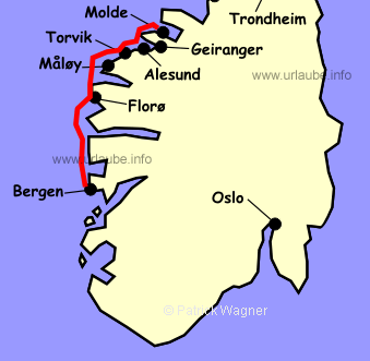
On new year's morning of the year 1992, here, at the Norwegian coast, the most devastating storm blustered with double hurricane force since time memorial; When the inferno was over, some parts of the coast equaled a battle field. On the sea, the hurricane orcan lead to some dramatical rescue missions. According to the news, "air and shipping traffic suspended". The people were instructed not to leave their houses. Only about the Hurtigrute nothing was announced. It navigated as always! In the Heröy fjord, protected by the Heröy Islands Skorpa, Nerlandsöy and Bergsöy, the ship returns on its way to Torvik back into a protected waterway. Torvik is the harbour for the approximately 8000 inhabitants of this island area. The stay at the harbour is only short, soon, the Hurtigrute continues its way and the passengers can recognize in the west the Heröy island Runde, that is the island that is deepest located in the Atlantic. The island equals a huge boulder, which edges fall vertically into the sea. In Runde, less than 100 human inhabitants live, but therefore hundreds of thousands seabirds, for which the sea is the food source. Runde is the most significant bird island of Norway at the south of the Arctic Circle. In good weather, Runde is visible from board until Alesund, built in art nouveau, is reached. )
)
)
As a fishhook thrown into the sea, this is the way the city,that is constructed on the three islands, is located at the bottom of the local mountain Aksla. There is not much imagination needed to think that a giant composed Alesund from the content of a toy box. From the Hurtigruten ship, one accesses in approximately 25 minutes and more than 418 stairs the view of Aksla, that beats the ones of Flöyen in Bergen in beauty. One sees the city in a fascinating bird's eye view and behind it, an immense number of big and small islands. But that wasn't enough: if one breaks away from this view and turn the sight in eastern direction, one has the massive peak of the Sunmöralpen before the face. Alesund is a young city, it did not get its municipal law until 1848, but long before this time it was a popular anchorage and harbour. Today, Alesund is the biggest fishing harbour of Norway with a large fishing fleet that is active during the whole year. )
)
)
)
The main features of the townscape of today were originated after the city burning of 1904. The fire practically destroyed the city. More than 1000 houses burned down in the city centre, more than 10.000 people became homeless. In the course of only 3 years, the city was rebuilt in art nouveau with national and international help. )
)
)
)
The german King Wilhelm II contributed significantly to the rebuilding of the city. For his generous financial support, he got a monument in Alesund. Willhelm II was a friend of the country. From 1889 to 1914, he went each summer to Norway on his yacht "Hohenzollern". Since the change of the route of navigation in the year 2000, today it is only possible in the winter time (October March) to visit unhurriedly Alesund for 3 hours. In the summer months, the stay is only short, as the Hurtigruten ships diverge now from the course they navigated for decades and do a side trip into the fascinating world of the Geiranger fjords, the most famous fjord of Norway. It was originated during several glacial periods and therewith of an important geological significance, it was put under the protection of the UNESCO as world heritage. )
)
What was and still is self-evident for the posh and big cruiser liners since decades, could at a time,when the tourism gets increasingly significant for the Hurtigruten, not left simply aside every day at the starboard side. The trip through this fascinating landscape of the tor-, Sunnylvs- and Geiranger fjord takes more than 3 hours. The steamboat has only short time left for its stay in Geiranger. The passengers for the land excursion are released and immediately after, the ship returns to Alesund. Those who stay on board experience the scenario again, this time maybe under complete different light and weather conditions. )
)
)
)
Those who become "unfaithful" to their ship in order to make use of the offered land excursion will surely get their money worth. The bus trip starts in Geiranger with the access over the serpentines of the eagle road to the mountain Örneveien. From here, one has an incredible view over the Geiranger fjord, its waterfalls and the surrounding mountain peaks. Thereunder the massive Dalsnibba, at which hillsides the street to the 1038 m heighted pass sidles up the Djupvasshytta. There, one is already in the area of the most northern apophysis of the Jostedal glacier. But the excursion continues into a different direction further to a pass summit of 624 metres until getting back to sea level at the Norddals fjord. We cross to Lingen with the ferry in order to get to the ascent to the pass of the Trollstiegveien heighted 850 metres. Over the Trollstieg with its 11 hairpin curves we continue down to Andalsnes at the end of the Romsdal fjord; After a short ferry crossing over the Lang fjords, one gets to the last stage up to Molde where one goes again on board of the Hurtigrute. If the pass over the Trollstieveien is closed or closed again due to snow, the bus drives from Lingen alongside the Storfjord back to Alesund. Before going back on board, the view of the Aksla that was already described before can be admired. During this excursion , the Hurtigruten ship returns to Alesund. Here, the traditional is retaken . )
)
)
The next harbour is Molde, that is locatred on the same named fjord facing on a southern slope the gorgeous panorama of the Romsdals Alps. Protected against the wind from northern and western direction by high mountains, the climate in this place makes many plants grow on the protected hills of the little city, that are normaly home at a much warmer climate: for example roses, this the reason why Molde - a little full-bodied - is also called the city of roses. Molde was established in 1742 and has 22000 inhabitants today. At night, the ship lands at Kristiansund before in the next morning Trondheim is reached. 
Back to the index Norway-Hurtigruten Author: Manfred Hofmann; Copyright: Patrick Wagner, www.tourist-guide.biz |
||