|


|
|
Hurtigruten Day 4: Arctic Circle Bodö Lofoten
Hestmannöy, Arctic Circle, Rödöylöva, Svartisen Glacier, Bodö and Lofoten, these are the catchwords of the 4th day of our journey alongside the Norwegian coast. The late riser is recomended to move a little earlier from his bed, in order to make sure that he will not miss anything of the landscape impressions and the events of the day, before in Svolvär on the Lofoten the day ends. During the night, the ship lands at Brönnöysund and Sandnessjöen. At 05.30 a.m., the steamboat leaves Nesna, around 07.30 a.m., the fictive line of the Arctic Circle is crossed; We glide into the country of the midnight sun. And in order that really nobody on board misses this event, the crew on the bridge activated the booming hooter. 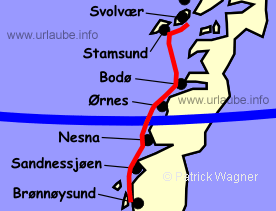
The Arctic Circle runs on 66°33 northern latitude through the island Hestmannöy, that can't be overseen on the port side due to its distinctive profile. The Artic Circle marks the most southern spot, at which in solstice on June 21st, the sun shines 24 hours and does not rise on December 21st. The time when it is absolute darkness here in the north, is most of the times over estimated in our latitudes. In the course of January, the sun rises in the whole northern Norway over the horizon and already from mid February, the light conditions are - supported by a long lasting dawn - comparable with our latitudes. The photographer should have a large provision of film material during a winter vacation. He will need it! Around 30 minutes after the crossing of the Arctic Circle, we can see the mountain Rödöylöva on the port side. The shape of this mountain is similar to a lying lion. 


From now, one should not stop watching the port and the starboard side. Somewhen, the Hurtigrute to southern direction passes us at the portside, and at the starboard side one can have a look on the far Svartisen glacier, provided the weather is clear. With its extension of 500 km², it is the second biggest glacier of Norway. Only the Jostedalsbreen further at the south between Sogne fjord and Nord fjord is bigger. It is more than twice as big and therewith not only the biggest glacier of Norway, but also the biggest mainland glacier of Europe. When the steamboat reached the Melöy fjord at the south of Örnes, the machines are stopped and a little boat swims alongside in order to collect the passengers that want to do an excursion to the Svartisen. This offer is possible to book on board from April until September. If the weather and the number of passengers permit it, then it is also possible to book this outside the mentioned time period. 


While the Hurtigrute gathers its way and soon reaches Örnes, the little boat wiggles its way to the Svartisen through straits and islands up to the Holands fjord. If one is a little lucky, one can watch some lesser fish-eagles in this marvellous landscape - thus, do not forget the binoculars! Anyhow, it should be continuously taken with one in the Hurtigruten. Flanked by the 900 m heighted Trolltinden, the Svartisen comes closer over the aforested shores of the fjord. Soon, one is in the country and after few metres, the glacier tongue of the Svartisen is in front of one. 
One continues with the bus further in direction to Bodö. If the time permits it, a stop is done at the Saltstraumen. The Saltstraumen is Norways strongest tidal current and is located a little southern from Bodö in the Salt fjord. Four times a day (between low and high tide), huge water masses are pressed through a sound with a width of 150 metres and the water masses stream in and out, 372 million m³ water with a speed of up to 37 km per hour. From Saltstraumen, it is not far to Bodö, where the Hurtigruten ship waits for its "backslide" passengers. 
If one abstains from the side trip to the Svartisen and stays on board of the Hurtigrute, there is no need to be bored at all. The coastal landscape offers enough distraction until the ship leaves the harbour of Bodö at 12 o' clock. There it heatedly attracts attention as in all ports with the hooter, before it takes its place at the dock. 
There are busily goings up to cast off at 03.00 p.m. Forklifts speed actively seesaw between the ship and the warehouses in order to onload and offload any kind of goods; And passengers of all ages come on board. 
There is hardly another port of the Hurtigrute where it is so hectic before the separture as it is in Bodö: Here, in the administrative center of 38.000 people of the province Nordland, there is a large airport and a railway line ends. Therefore, many new passengers came by train or by plane, but maybe only finalize a shopping tour, or come on friday back for the week end from school or work to their flats in the Lofoten. 
If then a storm does affect the air traffic, the hustle at the doch and on board is hard to outperform. And this is exactly what differs the Hurtigruten from a cruise, the guest on board is not under touristical shelter but also breaths the Norwegian daily air. Hopefully Neptun will keep this continuing! 
After the departure of the ship, the queue at the paymaster is cleared, the passengers have - depending on the weather condition and mood - taken their place at the deck or in one of the saloons. After an hour, the beacon of Langerode is passed and therewith, the crossing of the Vest fjord starts, a further open sea stretch that can be very tricky. 
As scheduled, Stamsund is reached at 06.45 p.m. But if there is a storm from south-west, then the surge is right at the dock and there is not even to think on a landing maneuver. On those days, the steamboat passes Stamsund and takes its course straight to Svolvär. 
But if the weather god is gracefull, then the encounter with the mountain peaks of the Lofoten that rise from the sea to an unforgeteable view. The jagged merlons of the Lofot wall extend over a length of 100 km. The mountains consist on granite and volcanic rocks. During the last ice age, the Lofoten were strongly glaciated; when then the ice melted, it left one of the wildest and most beautiful mountainscapes in the world. 
Each winter between February and the end of April, large flocks of codfish - attected by the warm gulf stream come here to spawn. This was the basis for the origination of numerous fishing villages at the east side of the whole island chain. Additionally, thousands of fishermen come from all over Norway in order to take part to the yearly fishing of cod. 
In the years after the second world war they were up to 20.000, but today, they are only approximately 3.000 per year. The fishermen that came from far away had to stay over night somewhere, and some had only the own rowboat as roof over their head. But also simple barracks were made of boards, the so called Rorbuer (fisher houses). When after the second world war the number of fishermen decreased, many of these cottages were empty or deteriorated. But then the tourism came and the Rorbuers became a popular accomodation; Each summer, vacationers of many countries come to the Lofoten in order to spend their holidays in these typical cottages that are located right at the water. Also the former Federal Chancellor Helmut Schmidt was a friend of the Rorbuer holidays. 
One also comes across to the Rorbuer by having a little walk through the port district during the stop in Stamsund. But watch out, keep always an eye to the departure times of the ship! 
As scheduled, the Hurtigrute leaves Stamsund at 07.30 p.m. with course to Svolvär. Here, the ship lands right at the market place, this is, beside the demurrage time of one hour, reason enough for a little walk. Svolvär is the capital of the Lofoten and has 4.000 inhabitants. Still today, the cod fishing with its catch of 25 to 50 million kg is the basis of live of this little city. Around 11.00 p.m., one hour after the departure from Svolvär, we navigate through the narow Raftsund. Stokmarknes, Sortland and Risöhamn are the landing places during the night, before a new Hurtigruten-Day starts in the early morning in Harstad. 
Back to the index Norway-Hurtigruten Author: Manfred Hofmann; Copyright: Patrick Wagner, www.tourist-guide.biz |
||