|


|
|
Hurtigruten Day 9: Tromsö - Harstad - Stokmarknes - Stamsund
It is already the 9th day on board of the Hurtigrute, and after the night visit in Tromsö, in connection to a short night, maybe still a little tired; Even if it is hard, one should anyhow try to be afoot before arriving in Harstad. As while the Hurtigruten in southern direction arrives at 08.00 a.m., the Hurtigruten in northern direction starts its way. The further daily routine and course of the fast steamer is dominated by both archipielagos Vesteralen and Lofoten. Two names by which a connosseur of Norway gets stars in the eyes. 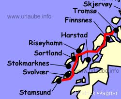
In Harstad, an excursion is offered during the whole year under the name "Island panorama Vesteralen" (see also day 5), that begins with a short tour through the city and a visit to the church of Trondenes. During the following bus trip, one experiences a part of the island world of Vesteralen. In Sortland, the harbour after the next, we go again on board of the Hurtigrute. it first leaves Harstad with northern course, passes at the portside again the church of Trondeneso, enters then into the Topp sound to the west. At the starboardside, there is the island Grytöya, at the portside Hinnöya, the biggest Norwegian island, that accompanies the course of the fast steamer up to the late afternoon. At the end of the sound, the island Andöya slowly appears from a distance. It marks the most northern part of Vesteralen. The southern area of the island is marked by up to 700 m heighted peaks, in the north, the island gets more flat, es dominieren Moore and extensive Moltebeer fields. The Moltebeere is a little nordic preciosity. Because of its vitamin c- concentration, it was always a popular "medicine". 
Risöyhamn appears with the Andoya peaks in the background. Before entering the harbour, the 4,5 km long Risöyrinne is passed. On this stretch, it was neccessary to boost a little in order to get enough water under the keel of the fast steamer. Here, a Sandbank that is located at approximately 1 m under the water surface and is an obstacle for the shipping. This is the reason why in the year 1875, people already began with the dredging works. In the course of the decades, the channel was deepened for several times, but not enough until the year 1922 to make the navigation for the Hurtigrute possible; When this work was finished, the inauguration took place with the presence of King Haakon VII. It is not exaggerated to say that with the inclusion of the Vesteralen, a new epoch was introduced for the fast steamer line and the archipielago, as until then, the Hurtigrute was forced to leave this area far in the west and to navigate at the east side of the island Hinnöya through the Tjeld sound. 
Once Risöyhamn is reached, one might wonder a little why the ship lands here at all, as the place has barely 350 inhabitants. But behind this place, there is the administration center Andenes with 6.400 inhabitants. Andenes, located at the northern tip of the island, is a beautiful fishing village. Its principal source of income was always the fishing. In the 17th century, when the fishing had to suffer some drastical loosings within the whole coast, this place became the supporting point for dutch whalers. Today, whale safaris are offered there, that offer the possibility to watch cachalots, orcas or minke whales. 
The stay in Risöyhamn is only short, during the landing, the Hurtigrute turns to southern course and passes right after leaving the harbour, the bridge of a length of 750 m that communicates Andöya with Hinnöya. Since the year 1978, a total of five bridges provide the communication of all major Vesteralen islands to the network of roads and the mainland without the need to take a ferry. 
An hour later, the bridge of a length of 961 m over the Sortland sound appears; At the starboardside, Langöya accompanies us,the third biggest island of the country. There, Sortland is located, it is, with its 4.000 inhabitants and due to its central location within the island area, the administration center of the Vesteralen. Most of the 17.000 inhabitants of the island live in residental areas at the western part of the island, in the right proximity to the fishing waters. As the other Vesteralen-islands, Langöya was also inhabitated in early times. There were items of the vikings found and the old localty names as Bö (house), Hov (heathen temple) or Vik (bay) are even originated before the viking time. 
Five hours passed since the departure in Harstad. At the backboard, there is still the coastal landscape corrugated by fjords and bays of the biggest Norwegian island. There, the highest mountain of the Vesteralen heighted 1262 m, the Möysalen, appears now. In the course but still far distant, the first peaks of the Lofoten appear. At the starboardside, the eastern peak of Hadselöya, the last Vesteralen-island, moves to the waterway. The entrance to the habour there, Stokmarknes, forms a bridge of a length of 1020 m, that communicated the island with Langöya. The topography of the island is completely atypical for Norwegian circumstances; Nearly round, it has no fjords at all or deep bays to offer. Its perimeter equals to a classic marathon stretch of 42,195 km, a thing that inevitably had to lead to the fact that each year in August, a national marathon takes place. 
In the year 1776, Stokmarknes obtained privileges of trading. From 1851 to 1939, each year a market was held. People of whole Nordland came to this place. Farmers and merchants with their boats and goods, impostors settled here with their tents, here, the population was entertained. With the lost of these markets during the second world war, a great value of nordic culture also got lost. 
In the year 1881, a milestone was put in the history of the Norwegian shipping traffic in Stokmarknes with the establishment of the Vesteralen Steamship Company. Here is the cradle of the Hurtigruten! A memorial was established to its founder, Richard With, in the Hurtigruten museum in the range of the sight of the landing stage. No passenger should miss this museum and the history of the steamship line. The biggest exhibit is the MS Finnmarken. Put into land and integrated into the museum, the ship that was built in the year 1956 represents the generation of the rebuilding after the second world war (see in this concern also the page History of the Hurtigruten). 
After landing in Stokmarknes, we approach the Raftsund and the Troll fjord with southern-east course. First, we cross the Handsel fjord. During this, our view goes seamlessly from the massive peaks of the island Hinnöya to the gorgeous coastal section of the Lofoten, that widely extends to the south west. The fast steamer obviously approaches the rock faces in front of us. An entrance into the narrow Raftsund is not visible at all. But somewhere there is a surprising "Open, Sesame" and immediately, the extensive arc of the kyle bridge is like a wide open gate in front of us. Behind this gate, there is a stretch section that belongs to the highlights of landscapes of the trip that cannot be beaten any more. 
We navigate into the Raft sound of 26 km length, and approximately after the first half of the way, we do a side trip into the Troll fjord in order to continue to Svolvaer, the next harbour. What is waiting there for the passengers is difficult to describe. This landscape has to be felt and absorbed by oneself. Those who do not get into the stress of the photo and video stuff but only look and gaze, are very lucky. 
The Raftsund communicates the archipielago of the Lofoten and Vesteralen. Peaks with a height up to 1000 m accompany the trip of the Hurtigrute, that glides as on a long extended, quiet river through a deep valley. It is difficult to say when is the most beautiful time in the sound. Here, each season has its special attraction and each day offers unexpected possibilities to experience this landscape in gorgeous moods of light and weather, as only the far north can generate. 
In the summer months, once the Hurtigrute left behind the most narrow places of the Raftsund, the bow truns to west, forces itself through the little Swartsund and takes its course to the entrance of the Troll fjord. Does it only seem to be or doeas it really get more quiet on board, when the ship slowly navigates into the Troll fjord, passing the steeply toering rock faces that are in one's grasp. Only 2,5 km long, therefrom, not much more than 100 m wide, surrounded by some bizarre peaks of a height up to 1146 m, the Troll fjord offers a view that is second to none and that is described by many passengers as the highlicht of the journey. Carefully, very carefully, the rock faces dangerously close, the Hurtigrute turns in the interior of the fjord and slowly glides back into the Raftsund. 
Sometimes it happened that huge flocks of Lofoten codfish got into the Troll fjord, a thing that lead to some fantastic catches. So it also happened in the year 1890 when it came to the Troll fjord battle. Modern steamboats put themselves abeam the entrance of the fjord in order to refuse the entrance to the fishermen in their sailboats and rowboats. They wanted to empty the fjord by themselves with the umbrella drop net. The fishermen eke out in their boats with rudders and boats hooks free entrance to the fjord out of sheer emergency. On second thought, this event was the first big fight between the high finance and the little fishermen for the resources of the sea. 
Shortly before leaving Raftsund, the little place Digermulen is located at the backboardside. In July 1889, the King Wilhelm II. visited this place for the first time and therewith laid the foundation for the Lofoten - tourism. Now, it does not take long anymore and the Hurtigrute turns to the west in order to approach Svolvaer. Up to the arrival there, the highest mountains of the Lofoten remain for long time in the range of vision at the starboard. 
One would pleasantly like to use the demurrage time in Svolvaer (see also day 4) to take a deep breath in order to assimilate the experiences of the day. But during the summer months, an impressive excursion by bus is offered here. The trip leads through the aboriginal, gorgeos landscape of the Lofoten and to spectacular view points. The beautiful fishing village Henningsvär is visited and by a slide show one gets introduced to the Lofoten at all seasons. In Stamsund, we return on board. 
And as all the scenic highlights viewed from the sea cannot be beaten any more today, it can't hurt to use this land excursion in order to put a cherry on the cake of this perfect day. Again, all hands on board, the Hurtigrute leaves Stamsund at 09.30 p.m. The world of islands of the Lofoten slowly remains at the stern of the ship, the open sea stretch of the Vest fjord is in front of us. We hope to have a night without storm! 

Back to the index Norway-Hurtigruten Author: Manfred Hofmann; Copyright: Patrick Wagner, www.tourist-guide.biz |
||