|


|
|
Hurtigruten Day 12: Malöy - Florö - Bergen
There are only a few hours left in the last day, then, 2.500 sea miles with the fast steamer alongside the Norwegian coast are a memory. Suit cases, duffel bags and rucksacks are packed. One stands a little sad in the cabin. Are realy 12 days already over since one has homely settled here but then only came for sleeping? Because the life on board of a fast steamer is not only within the four walls of a cabin. The fascination of a Norwegian landscape, impressions, moods and events have to be experienced from the deck. There, the pulse beat of the ship is transmitted to the passengers, the mind that is stressed by the daily life gets a rest. If one did not know this already before, then it gets rapidly clear that this trip is mot marked by the nightlife, animation, show or casino as it is the case on a luxury cruise, but form the daily life on board. It is marked by the landing maneuvres at the different airports, from the people one meets. People start conversations with each other and gets new contacts in the course of the time. Additionally to the passengers of the circular trip that are a mix of different nations, Nowegians and tourists join who only use the Hurtigruten for a certain stretch of the line. On the way, there is always something new, curious and interesting to see and to experience, in this concern, the last hours on board are not an exception. 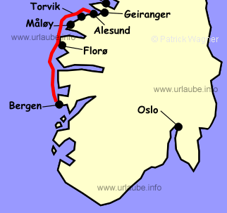
At night, the ship landed in Torvik, in the early morning, the early risers watch the landing maneuvre in Malöy. The place has 2.500 inhabitants and one of the biggest fishing harbours of Norway. Thousands tons of fish are brought here to land where it is processed and exported to numerous countries. Malöy is located at the estuary of the north fjord; While the ship moves here in a rude coastal landscape, at the east, there is the fjord located that cuts 90 km depp into the land, with its holiday paradises and bright fruit gardens . Beyond it, mirror-like lakes and thunderous shoots, feeded bty the glacier tongues of the mighty Jostedalsbreen. In the southern area of the fjord estuary, it is navigated into the narrow Skatestraumen, that can reach a velocity of many bends and that requires the full attention of the bridge crew. At the starboard, the 860 m heighted Hornelen is not overseeable. In the midsummer night and at the hibernal solstice, there are some witches on the peaks that visit this place in order to dance with the devil; Now, the Fröy sea opens to the south. At the west, the island bremanger accompanies us, at the east, the peak of the Alfor glacier covered with snow should appear soon. Now it is not any more far until Florö, that is located at the very outer tip on the mainland like a nail at a long and slim finger and which exposed position is protected by numerous islands in the west. The light house Stabben leads the way to the port; A beauty that should be watched during the entering and the put out. With its 5.000 inhabitants, Florö is the most western city of Norway; Established in the year 1860 with the fishing of herrings as economic basis, meanwhile some further economic sectors of course came out here to. For example Statfjord, the biggest oil and gas field of the Norwegian continental shelf, provided by Florö by one part. The stay here is only short, once the hatch is opened and the gangway extended, everything is closed and the trip continues. To the passenger's discomfort, the crew is in a hurry to get to Bergen. )
)
)
)
Adamantly, the Hurtigrute drives to the south where the two islands Askrova (at the starboardside) and Svanöy, that put the ship into their middle. Today, the former estate of Svanöy accomodates a scientific beneficence. The meaning of the beneficence is to keep and to use the natural basis of the coastal region. The manorial rococo main building is use as a centre of studies. What was used by the fishermen and sailors for centuries, of course cannot be overseen from the fast steamer. At the south west, the ridge heighted 481 m of the island Alden appears. The ridge is also called the "Norwegian horse". After that, the beacon of Geita is first approached, at the south of it, the island area Solund is approached. The same named community has 1.100 inhabitants and is supposed to consist on 1.700 islands. But probably nobody counts in such an exact way yet. In the tangle of the islands, one, as a passenger, tries to locate the way through the ship is going to navigate. The most wide parts between the islands are choosen and most of the times, one is completely wrong. It seems that the crew on the bridge have fn by choosing the most narrow places and laboriously, the ship manuevres through the Steinsund. Then, the entrance of the Sognefjord with the Sognesea greets us. The real fjord starts furthe rin the east, at barely 30 km distance of the waterway. The longest fjord of Norway is with a length of 1.038 m, also the deepest. The Sognesea that is 100 to 200 m deep, serves this fjord as a barrier and only permits the warm surface water to flow into the fjord. Thereby, the fjord remains free of ice during the whole year due to this help. )
)
)
)
The next "landmark" is the light house of Holmengra in the west. If it is passed, there is the estuary of the Fensfjord with the peninsula Lindas at the east, at which end there is the most western point of Norway on 4°56'58'' East. As a reminder (Day 7), the most eastern point at Vardö (Hornöya) is located on 31°10'10'' East. And then, everything happens much too fast. Accompanied by the islands and skerries, we arrive at the Hjeltefjord, that 12 days ago determined the way to the north, today, it is deviated to the east. The entrance to Bergen leads through the Herdlafjord, that is located between the two islands Holsenöy and Asköy. The first suburbs of Bergens already appear. Shortly afterwards, the two local mountains of the city are visible, first the 643 m heighted Ulriken, then the 400 m heighted Flöyen. In the Puddefjord, we approach the harbour and quay facilities. For the last time, we wince at the buzzing of the hooter - once long, then one short and again, one long. A piece of Norway came back. "The most beautiful sea journey of the world", unique and not comparable to anything in the world, ended. For now. 
Back to the index Norway-Hurtigruten Author: Manfred Hofmann; Copyright: Patrick Wagner, www.tourist-guide.biz |
||