|


|
|
Hurtigruten Day 10: Örnes - Arctic Circle - Brönnöysund - Rörvik
During this morning, we cross again the arctic circle, by the evening we leave northern Norway. Two unmistakable signs for the coming end of our journey. For some passengers, this will be even the last day on board, as they will already end the trip tomorrow morning in Trondheim. In order to make the farewell difficult for these passengers, we hope to have nice weather and a good vision, as the 10th day of Hurtigruten has, of course, again a lot to offer. After crossing the open sea stretch between the Lofoten and the mainland, our ship stands for 2,5 hours in the harbour of Bodö. This is a wellcomed possibility to get some sleep, if one has problems with sleeping during a stormy crossing. The next destination is Örnes that is left again before breakfast. Now, the legendary coastal panorama starts that will accompany us during the whole day. 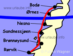
In the east, there is the gorgeous mountain world around the already known Svartisen (see also day 4) and the wild mainland coast that is carved by numerous fjords. In the west, a wonderful island panorama accompanies us. Approximately one hour after the departure in Örnes, the matutinal Hurtigruten - encounter takes place in Rödöyfjord and the fast steamer passes the island Rödöya. There, one sees at a bigger getting distance the Sphinx of the Rödöylöva. Once this picture disppears in the distance, we pay attention to the starboard and keep our view in course in order not to miss the crossing of the Arctic Circle. Right at the waterway, a little island that is arranged with a grid globe marks the fictive line over which we leave the land of the midnight sun. Acoustically, there is no need to worry to miss this event, as from the bridge, the crew again activates the booming hooter. Jumpy passengers should get prepared to this. In the west, cut by the Arctic Circle, there is the island Hestmannöy. On this island, bit by bit, the Hestmannen appears in the backwash of the fast steamer. He belongs to the giants and trolls that turned to stone and that entwine around numerous stories alongside the Norwegian coast. One of these stories is to be told later on. 
On the long way, the archipielago Traena that is located far in the west can be viewed in case of high visibility with its more than 400 little islands and skerries. Approximately 500 people live in this area. A little further to the south from there, there is the hat-shaped cone of the bird island Lovunden. More than 60.000 puffin couples have their homeland there. Then, not very far from the waterway, there is the island Luröya, where the property that is more than 200 years old of the scottish family Dundas, the ancestors of the priest and poet Petter Dass. 
As next, the island Tomma appears at the starboardside with the 922 m heighted Tomskjevelen. Together with Handnesöya and Hugla, these three islands flank the remaining way up to Nesna, that is located on a headland between Sjona- and Ranafjord. The Ranafjord cuts 70 km deep into the country. At the end of the fjord, the industrial city of 24.000 inhabitants is located, Mo i Rana. The old idyllic little harbour city Nesna with its 950 inhabitants is not included in the schedule of the Hurtigute but takes this task over. 
The next station is the nicely located Sandnessjöen. In the west, in front of the city, there is the island Dönna. There, the 858 m heighted Dönnamannen is on the qui vive on his area. Already long time before the arrival in Sandnessjöen, the cliffy island is visible at the starboard side. On this island, the is Dönnes, one of the few courts of nobility and big manors of nort Norway. Moreover, it is the only court in the north which history can be followed along general lines from the saga-time up to today. At the east coast, the old market town Björn is located, where in the 19th century, one of the biggest markets of Norway took place. There were up to 160 market stands and up to 3.000 people came on boat from near and far. Today, the new Björn market attracts more than 6.000 visitors in the second week end of July. 
But now back to Sandnessjöen. The name means place of landing for Sandnes. The homestead of Sandnes already existed in the saga-time and was the residence of the Viking Prince Torolv Kvedulvsson. In his area, he had to collect the taxes for the King Harald Schönhaar. Obviously not really satisfied with the results, one day, Harald personally went on his way to the north in order to destroy the court of Torolv. By this means, Torolv himself was also killed by the way. At that time, people were not sqeamish. But this event did not affect the further development of Sandnes at all. Thus, the property was for several centuries the residence of the magister and the location of the church. This church was moved in the year 1767 to Sandnessjöen, that since the 17th century established itself continuosly as a place of trading. The Hurtigruten, that had the harbour of Sandnessjöen on schedule from the beginning, provided a big boom. 
Today, the parish has 7.500 inhabitants and a multifaceted business: industry, fishing, agriculture(!), trade and administration provide jobs in nearly equal parts. Since the year 1991, Sandnessjöen is coummunicated with the mainland by the elegant Helgeland bridge with a length of 1.100 m. 
When the fast steamer leaves the harbour, one is probably having some delectabilities at the midday buffet. But due to this, one should not forget that we now slowly approach the gorgeous mountain panorama The seven sisters (De sju söstre). At the backboard side, they present themselves in their full beauty from north to south: Botnkrona 1072 m, Grytfoten 1066 m, Skjaeringen 1037 m, Tvillingen (twins) 979 m and 962 m, Kvasstinden 1010 m, Stortinden 910 m. The opinions about the best season for the Hurtigruten trip may differ, but the Seven sisters are without doubt the most beautiful when they wear their hibernal white bridal veil. of course, these seven beauties are also included in the nordic world of legends, but there is still to wait a little for this tale. 
Now we pass Alstahaug. Here, Petter Dass lived from 1689 to his death in 1708 and governated as a lord over his widespread community. This community literally adored his energetic but vivid parish priest. As a poet, Petter Dass described his loved homeland with a realism and an expresiveness, that distinguished him significantly form the other contemporary poets. Today, the Peter Dass Museum is situated in the former manse. 
A tangle of countless islands accompanies at the backboardside the further course of the Hurtigrute while it slowly approaches the island Tjötta at the backboardside. The island is whitness of all cult sites of the antiquity and tragic war events. Here, the Prince Harek von Tjötte lived, a powerful viking and one of the murders of the Holy Olav. During the excavations, 12 footprints of houses we found in astral aligment and burrial mounds of the viking period were exposed. To the contrary, the burrial ground for more than 7.000 russian prosioners of war and soldiers is of a completely different dimension. Additionlly, here also lay the dead persons the had to leave their lives during the downfall of the prisioner ship Riegel in the year 1945. In the waterway by Tjötta, the ship was mistakenly countersank by allied planes. The downfall of the Titanic with its 1.508 dead persons remains resounding throughout the land, but the fewest know about the 2.578 victims of the Riegel. In the afternoon, the coulourful houses of Brönnöysund that are located on a flat headland, welcome us. The nice little city that was already populated in the stone age, has today 3.000 inhabitants and is for the Norwegian car drivers the same thing that is Flensburg for german car drivers. The time in Brönnöysund is enough for a little walk, for example alongside the dock facilities, where the fishing boats in the foreground permit a photogenic view to the Hurtigrute. Back on board, one can unhurriedly watch the splendid environment up to the cast off. From the bow, one has from a certain distance, the kyle bridge of a length of 550 m to the island Torget and the harbour exit in the range of vision. For more than 100 years, the fast steamer found its tight passages, but what is visible makes one doubt a little on this possibility; When it is said "Cast Off", the ship inches its way forward with maximum 5 bends, willingly obeying the rudder, through the curvy exit. On the bridge, one is on the qui vive to the course and the smalles movements of the ship. After passing the most narrow part of the whole circular trip, a long extended island with colourful houses passes by at the starboard side. The hulk is so close to the land, that one can watch the indoor furnishing and the activities of the inhabitants. Then it is continued underneath the winding kyle bridge and shortly afterwards, the crew on the command bridge can retake the cup of coffee with an easy mind. What follows now is routine again. When the evenings are still bright and the vision is good, then the fast steamer does a turn to the west in order to facilitate a view to the 271 m heighted Torghatten to the passengers. Now, one might wonder why they make such a big issue for hammering 217 m? But the Torghatten has really something special to offer. 112 m above the sea level, a 160 m long, 25 to 30 m high and 12 to 25 m wide hole gapes into the rock face that can be admired from the Hurtigrute. Once the position with the best perspective is reached, the hooter buzzes. According to the science, this hole is originated by the frost and pounding of the waves at times when the land was located 110 to 120 m deeper than today; A nice explanation, but the Hestmannen and "The Seven Sisters" know that the Torghatten is of a totally different story: As, once upon a time, there was a Troll King who dominated on the Lofoten, right after Henningsvaer and his name was Vagekallen. His neighbour, King of Sulitjelma, dominated on the mainland. Vagekallen had a brave and daredevil son named Hestmannen, while the King of Sulitjelma had seven wild daughters. The daughters were friends of the beautiful Lekamöy, to whom Hestmannen kept an eye on, but without success. Yes, once, she even called him an idiot. One day, Lekamöya visited her friends (seven sisters) and in the evening, they spend the time by bathing in the sea. Thereby, they were espied by Hestmannen. 
By looking at the naked Lekamöya, a wild desire overcame him and he came at midnight on his horse to rob her. Within the last minute, the girls could escape to southern direction. The King of Sömnalfjell by Brönnöysund woke up by the noise and threw his hat in-between, when the furious Hestmannen wanted to shoot an arrow to Lekamöya. In this moment, the sun rose, and as the trolls cannot bear the sunlight, they turned to stone. But also the hat that was pierced by the arrow turned to stone. This hat is called the Torghatten ever since. Lekamöya, to whom the arrow was meant, could escape the most in southern direction, we will come across to her within the evening. 
Through this story, we reached the geographical centre of Norway. Supposedly, the Norwegian centre axle runs through the Tosentunnel, that together with the 70 km long and same named fjord is a part of the street communication between Brönnöysund and the E6. In the distance, the more than 1000 m heighted mountains of Bindal arise. 60 years ago, the gold-fever ravaged there. but the yield was always meagre, a bigger gold vein was never found. 
Ahead, the island Leka already appears, that is passed at the starboard side by the fast steamer a little later. At the southern tip, the 209 m heighted last legend figure turned to stone, the beautiful Lekamöya, alongside of the Hurtigruten; Now, it is not any more far to Rörvik, the capital of the island area Vikna, that consists on a swarm of approximately 6.000 islands. Therefrom, approximately 50 were still inhabitated in the 40s, today they are only 7 and more than 50% of the approximately 3.700 inhabitants live in Rörvik. 
The place has a coastal museum that is worthwhile to visit. it is easy to find at only a couple of minuted walk from the harbour; Right after the entrance, one stands in a shop of the 30s. it is still even possible to buy something. For example, raspberry sweets taken from a glass recipient, as it was usual in former times. Cod liver is also available, but the demand is low due to understandable reasons. The other rooms are about the fishing and the coastal shipping. Furthermore, there is an old class room with the high desk of the teacher and the old forms with the bulges for the penholder. The older generations will still remind this. We meet the Hurtigrute into northern direction at the dock. It casts off a quarter of hour before the one into southern direction. Slowly leaving the harbour, it offers, either in bright summer nights (get the cameras ready), or in the dark winter nights, a fantastic picture. Then it is the turn of the one into southern direction. It turns into the Naeröysund, navigates there underneath an impressibe hanging bridge and disembogues into the infamous open sea stretch of the Folda. Now it is time for going to bed, tomorrow morning we will wake up at Trondheim. Sweet dreams! 
Back to the index Norway-Hurtigruten Author: Manfred Hofmann; Copyright: Patrick Wagner, www.tourist-guide.biz |
||